Overview

Road surveying safety and efficiency challenges.

Road surveying safety and efficiency challenges are a common concern when working on busy roads, often requiring nighttime work and expensive traffic control measures. A recent incident highlighted the need for safer solutions. Additionally, RPS faced limitations with the SX Series’ slow scan times and the X Series’ accuracy issues on long linear projects, emphasising the need for more efficient methods.

About RPS

RPS, a division of Tetra Tech, has transformed its road pavement survey workflows by incorporating cutting-edge terrestrial laser scanning technologies. Damian Ling, Technical Director and Strategy Lead for Geospatial Solutions at RPS, brings over 20 years of surveying experience with a focus on using technology to enhance efficiency, safety, and client results, especially in complex road survey conditions.

Problem

Conducting surveys on busy roads presents significant safety and logistical challenges, often requiring nighttime work or extensive traffic control, both of which are costly and risky. A recent incident, where a car ignored safety measures and put our team at risk, highlighted the need for a safer and more efficient solution for road pavement and underground utility surveys.

RPS also faced difficulties with individual instrument solutions. While the SX Series provides accuracy, its slower capture time for full dome scans proved inefficient. On the other hand, the X Series, which relies on cloud-based registration in the field, faced accuracy issues when combining scans for long linear projects with limited vertical features. These challenges highlighted the urgency for a more streamlined and safer approach to road surveys.

Solution

RPS adopted a hybrid approach, combining the strengths of the SX and X Series scanners to achieve optimal speed and accuracy. The SX Series provided precise, station-based control, establishing a solid foundation for project accuracy, while the X Series efficiently captured detailed pavement data with rapid scanning capabilities.

By breaking large cloud-based registration sets into smaller chunks and tying them to SX Series scans using traditional survey control, RPS was able to maintain high accuracy while reducing field time significantly. This integration allowed for safer data capture from a distance, minimising on-road exposure and reducing the need for extensive traffic control.

Optimised field and office workflows ensured efficient data extraction and delivery, meeting stringent client requirements while improving overall project speed.

Key Advantages:

  • Enhanced Safety:

    Reduced on-road exposure and minimised traffic disruption.

  • Increased Efficiency:

    Faster data capture and processing, reducing project timelines.

  • Improved Accuracy:

    Integration of station-based and cloud-based registration techniques.

  • Comprehensive Data Capture:

    Detailed point clouds for accurate feature extraction.

  • Client Satisfaction:

    Meeting and exceeding stringent surveying standards.

  • Workflow and Technical Considerations:

    • RPS established primary control using the SX series, with additional X series scans for detailed data capture.
    • Scan spacing and density were optimised to ensure adequate coverage and overlap.
    • Field procedures were refined to streamline data capture and quality assurance.
    • Cloud-to-cloud registration was complemented by station-based control to enhance accuracy.
    • Data processing workflows were optimised in Trimble Business Center (TBC) to meet client specifications.

So why Scanning?

Adopting scanning technology has greatly improved RPS’s data collection process in multiple ways. It makes data capture more efficient, enabling RPS to gather more information in less time. This increased efficiency also reduces the need for return field visits if any features are missed during conventional surveys.

A key advantage of scanning is that it allows data capture on active sites, enabling work to continue with minimal disruption to traffic and surrounding areas. It also streamlines our office workflows by providing more accurate, detailed data, which leads to better models and easier issue resolution. Additionally, it offers more opportunities for clients to visualise site information in new ways.

Scanning is also safer than traditional methods, particularly when working on roads, as it reduces the need for traffic control, cutting both safety risks and management costs. It’s more efficient than terrestrial reflectorless methods and perfectly suited for projects ranging from 500 metres to 2.5 kilometres.

In summary, the integration of scanning technology has enhanced safety, efficiency, and data quality, making it an essential tool for our surveying projects.

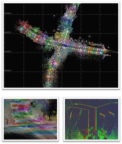
RPS Scanning point clouds
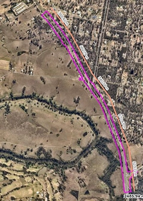
Juers Road Scan

Project Example – Juers Road

RPS’s first major road pavement scanning project using the SX Series involved a 900-meter stretch of road that required a full detail and feature survey from property boundary to boundary. For this, 16 primary control points, spaced approximately 100 meters apart, with scans conducted at each of these locations. Additionally, 50 secondary SX12scan stations, spaced roughly 30 meters apart.

The scanning process took about 28 hours over 4 days with a solo operator, capturing a total of 423 million points. After processing the data, quality assurance was carried out by checking 87 independent measurements captured with a total station. The average deviation between the observed points and the ground-classified point cloud was less than 5 millimetres across the entire site, well within the tolerances required for RPS’s surveys.

From the point cloud data, over 1,600 CAD points were extracted, feature-coded and attributed in TBC (Trimble Business Center) for inclusion in the final deliverables. This project was a major success, highlighting key benefits of using the SX12s for road pavement surveys, including:

  • The ability to capture large volumes of data quickly.
  • Ensuring high precision and reliable results.
  • Reducing the need for surveyors to be physically on the road, thus improving safety.

By using the SX12, RPS met client expectations, delivering high-quality data in an efficient and safe manner. This project served as a benchmark for future surveys, enabling RPS to refine and improve its processes.

Benefits and Issues Encountered

The key benefit was the elimination of night work and direct pavement surveys, significantly improving safety and reducing fatigue. Working during the day also minimised scheduling challenges and the need for traffic control, lowering costs and traffic disruption. Additionally, the ability to capture missing features and overhead data without extra field visits streamlined the process. Since the scans were taken on established control points, the point cloud data was already coordinated, enhancing workflow and efficiency compared to traditional scanning methods.

However, challenges included the longer time required for full dome scans compared to standalone scanners, and the need for additional scans to cover the area. The scanner’s range on pavement surfaces, particularly with asphalt’s reflectance properties, also posed difficulties. Furthermore, the size and weight of the instrument created logistical challenges for staff moving between scan stations.

Despite these issues, the benefits of using the SX12 far outweighed the drawbacks, and RPS refined its processes to mitigate these challenges.

The X Series Experience

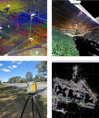
The release of the X Series presented an opportunity to enhance RPS’s capabilities. Smaller, lighter, and faster than the SX12, the X9 was perfect for road projects where portability and speed were crucial. Initially tested on typical laser scanning projects like building surveys and substations, it performed exceptionally well. Impressed by its effectiveness, RPS saw potential in using the X9 for road pavement capture to further reduce field time.

While the X9 wasn’t designed to replace the SX12, it complemented its use. Its quick setup and fast scan speed, along with imagery capture, made it ideal for projects where time efficiency was key. The X9’s versatility was evident in applications ranging from intersections and road pavements to hospitals, demonstrating its effectiveness across various environments.

RPS X Series Scanning

Lessons Learned:

Managing large datasets requires careful planning and segmentation of the project, especially in environments with limited vertical features where cloud-based registration can be challenging. By combining station-based and cloud-based registration techniques, RPS achieved optimal results, enhancing both accuracy and efficiency. Continuous refinement of workflows proved essential to maximise performance. The use of station-based registration as a framework for cloud-based registration was vital for maintaining accuracy in linear projects.

RPS learned that integrating advanced scanning technology, such as the X Series and SX Series, not only improved safety and efficiency in high-risk surveying environments but also significantly reduced manual operations, offering clients a more effective solution with enhanced data accuracy.

Workflows

Field Workflow:

In the field, RPS begins by briefing the team on project details, scan spacing, settings, and photo requirements. The maximum number of scans is set up, and on-board registration is utilised. Most scans register automatically, while others are manually linked or reattempted. If needed, additional scans are considered to ensure full coverage.

Perspective Workflow:

Back in the office, RPS exports the data to a PC with Perspective software for refining and colourising the point cloud. Scan registrations are reviewed and corrected, misalignments adjusted, and failed scans manually linked. The project is split into registration sets based on SX12 stations or GCPs.

TBC Workflow:

In TBC, RPS imports SX12 data into the correct coordinate system and uses pairwise point cloud registration tools. Registration is based on SX12 scans as the reference, optimised for accuracy. A visual inspection for vertical object alignment is conducted and filters are applied to refine and manage the data for final deliverables.

Conclusion:

By integrating the Trimble SX and X series instruments, RPS has greatly enhanced its road pavement survey workflows, improving both safety and efficiency. This strategic approach has ensured the delivery of high-quality, accurate data that exceeds client expectations.

With the support of UPG and its technology, RPS successfully navigated the challenges of road surveying, achieving exceptional results. This case study highlights how advanced scanning technology can transform road surveying processes, reducing risks, streamlining workflows, and consistently meeting stringent project requirements.