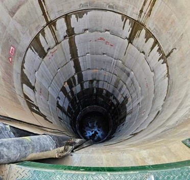
Vertical Shaft Mine Surveying Technology

Brett Grocock, owner and authorised mine surveyor, Element Geospatial (formerly Mine Survey Plus), addresses how mine owners can address the challenges of vertical shaft mine construction through the use of surveying technology and innovative techniques

This article by Brett Grocock of Element Geospatial was originally published in the March 2025 issue of GeoDrilling International. The original article can be found here. (Note: Access to the full article on GeoDrilling International may require a subscription). See LinkedIn post

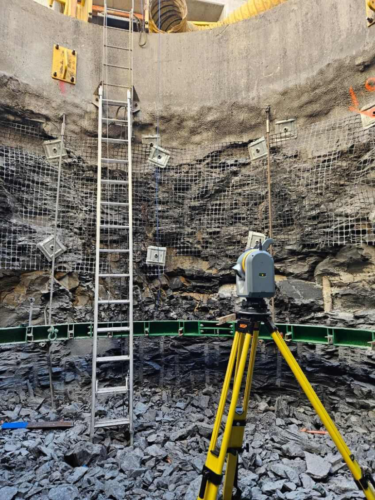
Surveyor using Trimble SX12 in a vertical mineshaft.

Over time, mine operators must assess the future value of mineral resources far below the Earth’s surface as ore accessed in shallow pit mines is depleted.

While decline, ramp, or incline shafts are suitable for mining surface deposits, vertical shafts can be more economical for transportation of people and ore, utility corridors and ventilation at greater depths and allow miners to extract otherwise inaccessible minerals.

As existing mines expand and deeper ore-bodies are discovered, adding vertical shafts is often preferred, if not necessary.

The deepest mines today reach 4km (2.5 miles) under-ground and are becoming increasingly automated, which improves safety and sustainability within the mining operation.

Constructing these underground mines requires specialised engineering skills and equipment; only a handful of companies possess the necessary expertise. Element Geospatial (formerly Mine Survey Plus), is a Perth-based company.  It’s a stand-out in the niche area of surveying, having worked in more than 90 mines in 14 different countries.

In particular, Element Geospatial is well-versed in managing the challenging environment of surveying vertical shaft projects.

Surveying is a crucial part of vertical shaft mine construction to ensure work is proceeding according to design with high accuracy and precision. The biggest challenge is collecting as-built measurements with speed and accuracy under adverse conditions. Element Geospatial provides information that reduces rework and avoids wasting materials.

This is achieved by quickly identifying discrepancies and accurately estimating concrete volumes for the shaft liner.

Element Geospatial invests heavily in the latest technology available, such as scanning total stations and global navigation satellite system (GNSS) receivers, to ensure the highest levels of safety and performance at its mining projects around the world. Advanced engineering and surveying solutions and 3D analysis now provide detailed information throughout construction to expedite the workflow.

UNIQUE ENVIRONMENT

Vertical shaft surveying presents unique challenges compared to above-ground surveying, frequently presenting testing and difficult and uncomfortable conditions due to the following characteristics:

  • Groundwater: Equipment must be rugged and water- proof to withstand exposure to salty groundwater in the shaft.

  • Airflow: Constant airflow in the shaft acts like a wind tunnel, affecting plumb lines and total stations.

  • Long hours: Surveyors must be available 24/7 to avoid delaying construction work; they work 12-hour day or night shifts. In remote areas, workers are flown in and out on a weekly or bi-weekly rotating basis.

  • Time pressure: Surveyors must quickly verify measurements after blasting to identify overbreaks/underbreaks before the next concrete pour. Processing data in real-time allows surveyors to communicate results within minutes of returning to the surface. For example, surveyors may have only 90 minutes to survey a 6m high and 5.5m diameter vertical shaft, process the data and calculate the volume of concrete needed to validate proper thickness and design.

  • Sightlines: In a 5.5m diameter shaft, the setup is in the centre of the stage, and sight lines are very short, which is less than ideal for geometric calculations such as a resection.

  • Obstacles: Plumb lines snag on forms, tapes rip off walls, steady brackets are hit, shutters are damaged, etc., making surveying more difficult.

  • Accuracy: Tolerances for shaft construction are extremely tight, reflecting the critical nature of the infrastructure being built. The correct amount of rock/soil must be excavated, and the concrete has to be a certain thickness so that prefabricated horizontal steel buntons will fit.

SPEED AND ACCURACY

After consulting with UPG (Ultimate Positioning Group), Trimble’s Australian distributor, Element Geospatial, purchased its first Trimble SX12 scanning total station to use on the Havieron decline project in Western Australia in 2021.

The SX12 scanning total station combined a high-accuracy robotic total station and a 3D laser scanner in one instrument. A small green laser spot (3mm diameter electronic distance measurement (EDM) laser spot at 50m) was especially helpful for underground applications like staking out lines, and the robotic technology withstood the harsh conditions found in a shaft construction site, such as dust and moisture.

The value of the scanning/total station technology was so beneficial that Element Geospatial purchased a second SX12 scanning total station to use on an underground mine project in Australia. This expansion effort involved the construction of two 1460m shafts in a raised bore. The shafts were constructed for ore hauling with guides, buntons, and brackets to secure water, air, and utility pipes. Working from the top down, surveying and installation of the concrete liner was scheduled to take 18 months plus the time to erect the steel structure and fit out the shaft.

Element Geospatial is also employing the SX12 scanning total station at an Australian coal mine that requires twin ventilation shafts descending 500m. This drill and blast project proceeds in 6m increments, with the surveyors checking the as-builts in between blasting and pouring concrete.

ADAPTING WORKFLOW

In recent years, laser scanning technology has become an increasingly important part of the workflow. Thorough documentation of the shaft walls serves multiple purposes:

  • Overbreak and underbreak analysis: Scans reveal areas where too much or too little rock has been removed during blasting and excavation.

  • Volume calculations: Creating a model from the scan data, surveyors can accurately calculate the volume and thick- ness of concrete needed for each

  • As-built documentation: Scans provide a detailed record of the shaft’s actual geometry, which is crucial for future planning and maintenance.

As the shaft progresses, the as-built measurements are verified against the design after each blast phase and before the next row of forms are filled with concrete. To collect the necessary data, the surveyor is lowered into the shaft on a work stage suspended from a hydraulic arm to perform the next setup. The arm keeps the cage off the wall and holds the cage relatively stable so that movement does not skew the results.

Element Geospatial defines shaft control using already established primary survey control marks at the top of the shaft, co-located with plumb lines and plumb line prisms installed at the surface. Surveyors then use a remotely controlled winch to drop the plumb line suspended on a wire from the surface, with a 20kg weight at the bottom to keep it from moving. Small brackets are installed every 50 – 60m to guide the wire through a narrow opening, which helps minimise sway over hundreds of metres and improves the accuracy of the plumb line system.

The surveyor resects off prisms as in a conventional survey, but the prisms move slightly due to airflow in the shaft, and extra rounds are required to obtain an accurate horizontal position with the SX12 scanning total station. Element Geospatial uses Trimble Access field software on a Trimble TSC7 controller to collect the total station readings to ensure an accurate and adequate resection is performed.

RAPID DATA PROCESSING

Element Geospatial uses Trimble Business Center (TBC) software for rapid data processing and was instrumental in developing its vertical shaft capabilities. Its feedback was incorporated into the product design process, ensuring that real-world perspective was applied to these specialised capabilities.

Once the shaft is scanned, the surveyor ascends to the surface, loads the scan into TBC and removes noise, such as ladders or steel cables, with the surface inspection transparency tool in Trimble Access. A heat map is generated to show deviations from the design. After creating a solid cylinder model, the opera­ tor calculates the volume of the ring of concrete, prints a report, and delivers the information.

Accurate volume calculations are increasingly important as contractors seek to reduce concrete waste to minimise the project’s carbon footprint and be properly compensated for work completed. The 4.1 billion metric tons of cement, a key ingredient of concrete, manufactured worldwide in 2023 is estimated to contribute 8% of the world’s carbon dioxide emissions.

The combination of field data collection using the Trimble SX12 and subsequent processing in TBC enables a quick turnaround of critical information, meeting the demands of tight construc­tion schedules. Operators can automate the as-built data collection process and provide near real-time feedback to the excavator operators, which is typically one of the most time-consuming tasks in shaft construction.

“We’re under a lot of time pressure, so the equipment has to work well all the time,” James Gianatti, senior surveyor at Element Geospatial, said. “We do a 10-minute scan, colourise it and load the scan into TBC to quickly analyse whether too much or not enough material has been blasted off the walls.”

By eliminating trips to the office, processing the files on PCs, pro­ducing a hard copy report and then passing the information back to supervisors and operators, infield scanning, registration and processing significantly expedite the surveyor’s work.

MAKING A JOB EASIER

Surveying a vertical mine shaft poses significant challenges while requiring a high level of accuracy.

Element Geospatial welcomes any technology that both expedites the process and enhances results. Incorporating the Trimble SX12 scanner and TBC and Trimble Access field software into their workflow delivers noticeable benefits.

Comparing scan data against the design profiles to verify conform­ance while in the field has proven to be a time saver on several vertical shaft projects in the past few years.

The 3D scan provides an added layer of visual communication and immediate feedback on any course correction that may be needed. Better accuracy translates into less rework and helps the team meet ambitious construction schedules.

3D scan model of a vertical mine shaft.

When the pressure is on to complete construction projects quickly and efficiently, surveyors can enhance their performance by applying new scanning technology that produces more accurate information under adverse conditions. Vertical shaft surveying is just one of many types of challenging projects that benefit from highly skilled surveyors and modern survey technology to achieve improved workflows and complete jobs successfully.